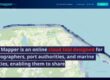
Rapid climate change and the economic situation necessitate the implementation of modern solutions to digitize the monitoring of coastal zones. Port Mapper is an online cloud tool designed for hydrographers, port authorities, and marine entities, enabling them to share and distribute spatial data among marine entities.
Due to the ongoing climate change and the increasing intensity of coastal areas’ utilization in the economy, there is a growing need for continuous, harmonized monitoring of coastal zones. The rising demand for goods transportation has a progressively significant impact on the requirement for optimizing transportation chains, including the maintenance of maritime routes and transshipment infrastructure (ports, docks, and port approaches). These areas must comply not only with safety and environmental protection requirements but also with the growing demands of the mentioned earlier economy.
In this context, making appropriate decisions based on real-time and up-to-date data is crucial. This involves utilizing suitable technical and non-technical means to maintain coastal and shoreline infrastructure. It also requires easy and rapid access to credible, current information about the current shoreline configuration, the state of the seabed in the coastal zone, and areas near maritime transport routes.
Furthermore, to accurately determine trends in changes, such as sediment deposition or shoreline erosion, access to reliable archival data, information, and previously conducted measurements is essential. These resources should be available within one coherent system.
Port Mapper is intended for entities whose activities are related to monitoring coastal zones and shorelines, including port authorities and managers, coastal protection services, maritime administrations, measurement companies, shipowners, managers of hydrotechnical infrastructure (such as offshore wind farms), producers of maritime navigation software, and bathymetric map makers.
Key advantages of the system:
- The ability to remotely monitor waterway conditions for maritime administration (in coastal areas).
- The ability to remotely monitor the conditions of port basins for port managers.
- The capability to analyze trends in sediment transport changes for maritime administration and port managers.
- The option to archive and share data with other entities without the need for manual data transfer between computers.
- The capability for remote identification of areas requiring dredging (seabed deepening) for port managers and maritime administration.
- The ability to assess trends in coastal shoreline erosion for port managers and maritime administration.
User registration and login:
In terms of this functionality, the Port Mapper system allows users to create an account by providing their email address. After logging into the system, registered users gain access to extended functionality, such as 3D data visualization of measurement data and the ability to upload and view measurement data.
If you are interested in our solution and would like to learn more details, please contact us via email andrzej.chybicki@inero-software.com